7 Easy Steps to Make Your
Own Plat Map
From “Legal Description” of
Trees, Rocks and Waterways
Using My Gr Gr
Grandfather’s 1847 deed as an example
FIRST write the boundary measurements in the deed (often after the word “viz” or the phrase “to wit”) in list form. (It may be easier for you later to spell out E-W-N-S.)
A. Beginning at a honey locust corner to Patterson Brandenburg and James R. Rubart
B. Thence with Brandenburg’s line DOWN THE CREEK South 50° East 68 poles to a stone witnessed by a sugar tree sycamore and white walnut corner to said Brandenburg
C. Thence with his line East 40 poles to a small hickory corner also to said Brandenburg
D. Thence with his line North 71 ½ ° East 22-1/2 poles to two small elms corner to said Brandenburg
E. Thence North 69° East 36 poles to a sugar tree beach and hickory corner to John Brandenburg
F. Thence with his line South 2° West 100 poles passing his corner 52 poles to a stone witnessed by a sugar tree
G. Thence West 159 poles to a hickory and sugar tree
H. Thence North 3° East 110 poles to a stone in said Rhubarts line
I. Thence with his line North 38° East 15 poles to the beginning [where the honey locust is]
SECOND don’t pay any attention to the neighbors’ names. They may help you genealogically since they may be relatives, but that’s usually all. Also, don’t pay any attention to the rocks and witness trees. The witness trees were identified just to help the owner with chinks chopped in them by the surveyor and are probably non-identifiable today (though I have seen a pile of witness rocks from a survey in the 1700s in N.C.). What you do need to know is what the measurements mean.
Link – 7.92 inches
Foot – 12 inches
Yard – 3 feet/36 inches
Pole/Rod/Perch – 16.5 feet
Chain – 66 feet (100 links)
Square Pole – 272 square feet
Mile – 5,280 feet
Acre – 43,560 square feet
Rood – ¼ acre
Get a piece of paper and look at the longest section of poles in your ancestor’s deed. In my William Maddox’s case, it is G. – 159 poles. From that, decide how many inches or centimeters (whichever kind of ruler you plan to use) or part thereof will represent a pole. For my plat map, I made one inch equal 20 poles. Write that in the top corner of your paper as a constant reminder for now and later. Therefore, his 159 poles was nearly 8” across my paper.
I made 1” = 20 poles
THIRD you need an angle/degree gauge in the shape of a half circle. I picked mine up at a dollar store in a package of other measurers such as triangles and straight rulers. Mine is cheap plastic and about 4” by 2”. It doesn’t have to be large or fancy. If you can’t find one, make one. Just draw an exact circle (360°) on cardboard or heavy paper, then draw a line marking half (180°), then two more showing fourths of the circle (90°), and more lines showing eighths (45°), and so on.
Now notice in the legal description above I identified the number of poles separately from the number of degrees E, W, N or S. You need to identify on your paper where E, W, N and S are. I was lucky in William’s survey, because the 159 poles were straight West. But after that, were degrees of direction. It is a good idea to start with a line that is straight E, W, N, or S. or as close as possible on your deed.
FOURTH let’s start drawing.
I set the top of my paper as N, the bottom S, etc. The first line I drew for my William’s land was “G. Thence West 159 poles “ eight inches across the bottom of my paper right (East) to left (West). That was easy.
The second line was “H. Thence North 3° East 110 poles” The first direction listed (North) is the main direction. But this wasn’t straight north. It was North, but over toward the East just slightly ~ 3°. So I placed my degrees gauge on my first line (the West 159 poles). North is 90° from West (marked on the gauge), so I counted three markers/degrees to the right (East), and placed a little dot there.
Then I decided how many inches 110 poles was on my scale. Remember, I decided I would let 1” = 20 poles. So my second line would be 5 ½”. Using my little dot for the angle as my guide, I drew a second line from the left (west) end of my first line up my paper 5 ½”.
And I did this for each boundary line listed in the deed.
FIFTH don’t be discouraged if an angle takes you off the edge of your paper. Just tape a second piece of paper there and keep on drawing. When you’re done, you may have 4 or 5 pieces of paper taped to your original. That because, unless you’re a math genius and can tell just by glancing at your legal description where best to start your first line in your drawing, you may not draw that first line in the best place for everything fitting on your original piece of paper. When you’re done with your drawing, just trace your plat map onto a single piece of paper.
SIXTH get a good map of the county where your ancestor’s land was. Make sure that part of the county didn’t break away later and become another county. To find out, do an internet search like this: Bracken, KY, genealogy. The genealogy site will tell you when that county started, out of which mother county, and when/if it was subdivided into other counties.
A good place to get a good map is www.mapquest.com .
SEVENTH now the fun part starts. On 99% of deeds there is a waterway listed. This is your big clue on how to find the location of his land. My William’s was
B. Thence with Brandenburg’s line DOWN THE CREEK South 50° East 68 poles to a stone witnessed by a sugar tree sycamore and white walnut corner to said Brandenburg
Most deeds listing a creek added “in its meanderings” or “as it meanders”. This one didn’t. But it did give a general direction the creek was flowing at that point: South, but 50° in an Easterly direction for 68 poles.
Sometimes when you make your drawing, you will end up with the last point not meeting up with the first point at the first corner. That’s usually because of the meanderings of your river or creek. Make your adjustment there.
On my plat map, I traced the creek line with a blue marker so it would stand out. Now look at your map of the county and look at the creek named in your deed.
[As an aside, if it doesn’t show up on any maps on the internet, you’ll have to write the county courthouse and ask for a county map. You’ll need to send a large stamped, self-addressed envelope. The maps are free, but they might appreciate a donation for their time. The maps are often about 2’ by 4’, so fold up a piece of paper that large and place it in your large envelope, take it to the post office and get it weighed so you know how much postage to put on it. Their map will show everything.]
It is doubtful your creek will meander in exactly the same direction for the same number of poles/feet more than one time its whole length. (Remember, creeks aren’t usually longer than a county and are usually just a few miles). Some ancestors were lucky enough to get land right on a river, but not many ~ it cost a lot more.
Where the creek in your map goes in the same direction as listed in your deed and for the same number of poles/feet, that is where your ancestor’s land was. Now take your plat map and reduce its size so it is the same scale as your map, and draw his land on your map.
The feeling is exhilarating. And even more so when you go to where that land was and walk it. And think about your ancestor as a little boy wading, swimming and/or fishing in that creek. And of his mother going to do the laundry there. And of his father maybe digging trenches from it to water his crop, or putting up a fence on the other side so his cattle didn’t wander off after getting a drink. You’ll spot the hill and wonder if that’s where their cabin was. And the valley and wonder if that’s where the log barn was and walk around up there looking for possible signs like old foundation stones. And you’ll wander around wondering if there are any tombstones lying on the ground. Your imagination will have a field day! Then your ancestor will be more real than ever.
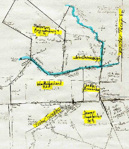
LAST you may get so proud of your work , you might want to get the neighbors’ deeds (especially if they’re related) and draw them to attach to your direct ancestor’s plat map. I did. To the East and NE was his father-in-law, John Brandenburg. To the SE was his brother-in-law James Hughbanks. To the Northwest was another brother-in-law Patterson Brandenburg. And in the middle was the creek that bordered all their land.
You may see faint lines also on my sample map. Those are the borders of the current owners. When land is subdivided between the children for several generations, its later plat maps don’t even resemble the one when your ancestor lived there. In my ancestor’s case, someone a few generations later started buying up some of that same land, but by now it was a different shape.
Good luck. And have fun.